


If you have lived in the Pacific Northwest long, it is likely that you have traveled part of the Oregon Trail. Olympia is the end point of an estimated 2,000-mile trek coming west from various towns in Missouri. Markers were place by the Sacajawea Chapter of the Daughters of the American Revolution all the way from Vancouver, Washington to Olympia. So take a day trip to these Oregon Trail markers in Thurston County. (Please be advised that though markers were in open fields 100 years ago, they are now in narrow roadside locations.)
 Tenino Trail Marker
Though not placed by the DAR, the marker on the main road through Tenino, begins the chronology of trail commemoration. On February 12, 1906, much of the town joined Ezra Meeker in celebrating the placement of the small monument. Stores in town closed, and children left school to join the event. It is located on the northwest corner of Sussex Avenue, state route 507, and Sheridan Street in Tenino. A rectangular block of sandstone, cut from the Tenino Quarry Company that was nearby, rests with the simple inscription “Old Oregon Trail 1844-53.”
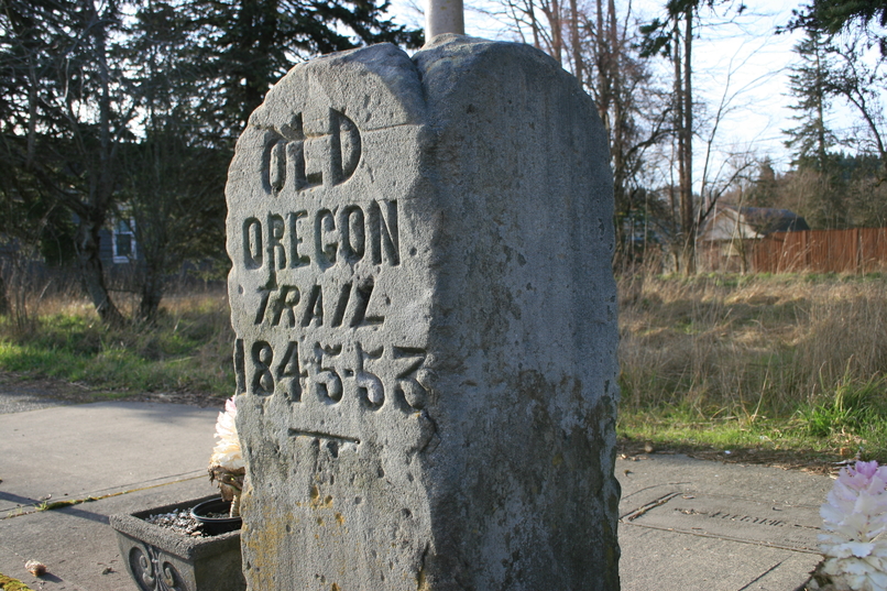
The idea of marking the trail and preserving it started with Ezra Meeker. In 1906, at the age of 75, Meeker, who had first traveled west across the trail himself, began a campaign to garner attention and secure federal preservation funds. Meeker’s 1852 path was being erased by way of land development. Settlers, who had purchased plots of land were now plowing and changing the terrain. Meeker started his pilgrimage in Puyallup, and he traveled east along the trail setting commemorative markers along the way. One of his early stops in Washington was in Tenino where he laid the first inscribed stone.

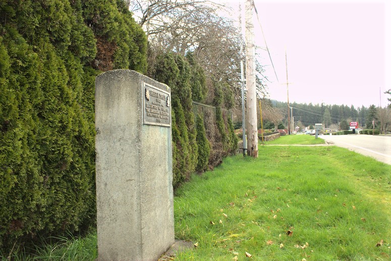
Tenino Scatter Creek Bridge Marker
Retracing the path of the Oregon trail on your way to Puget Sound from Grand Mound means visiting two monuments in Tenino. The second stop is the DAR marker near 420 Old Highway 99 across the street from the Tenino elementary school. It stands on the east side of the road, just south of the Scatter Creek Bridge. The significance of the location is the historical Hodgson Station. Stephen Hodgson settled the land for farming in 1851 and later became the postmaster. As an intersection for travel from Grand Mound, either continuing on east to Yelm or turning north toward Tumwater, the station was also a stagecoach stop. The commemoration for this marker took place at 2:30 p.m. on September 10, 1916. The children were dismissed from school, and they led the gathering crowd in a flag salute.
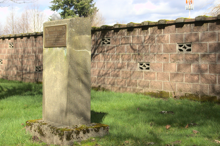
Grand Mound Marker
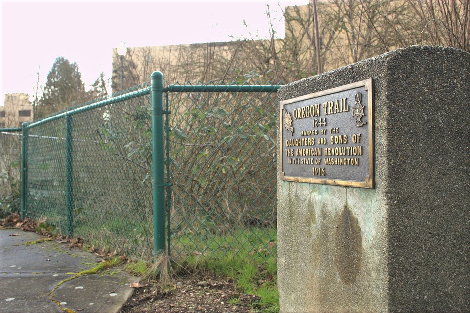
Grand Mound signifies where the Cowlitz portion of the Oregon trail enters what is now Thurston County. It is here where an easterly turn took, and still does take, travelers to Tenino and Bucoda. On the day of this marker’s commemoration, Governor Ernest Lister and honor students from the state school for girls were present at the festivities. This marker is located at 20639 Old Highway 99 near Highway 12 and Grand Mound Way, between two cedar trees, west of Interstate 5. The inscription on the marker reads, “Oregon Trail 1844, marked by Daughters and Sons of the American Revolution in the State of Washington, 1916.”
Bush Prairie Marker
On the same afternoon as the events near the Tenino Elementary School, other students also celebrated a newly placed marker several miles to the north. This marker is located at 8820 Old Highway 99 just south of 88th Avenue, on the east side of the highway. The significance of this location is the George and Isabella Bush 668-acre farm, the first settled farm north of the Columbia River. George was the first Black pioneer to own land in Washington Territory. The farm, settled in 1845, was a well-known place of friendship and community support and is still in operation today as the Bush Prairie Farm. On September 10, 1916, the flag was raised, and school children placed flowers at the base of the new monument.
Tumwater Marker
The second to last marker is at the southeast corner of Boston Street and Deschutes Way near Tumwater Falls Park. The significance of the location is partly the previous home site of Ira Ward. Ward, like the settlers who arrived before him, operated mills in this prime location for waterpower. This marker was erected and commemorated on August 18, 1916, and a quartet sang the “Star-Spangled Banner.” Chaplain and pioneer P.D. Moore said the invocation to a crowd of about 600, which included a number of pioneers. Four grandchildren of state pioneers officially accepted and unveiled the monument.
Sylvester Park Marker, Olympia
On the northwest corner of Sylvester Park in Olympia, at Legion Way and Capital Boulevard, sits the final marker. This native granite boulder’s inscription reads, “Marking the end of the Oregon trail 1844.” The significance of the site is the exact location of a wooden blockhouse that served as a safe haven during 1855-1856 conflicts. The park itself, donated by Olympia founder Edmund Sylvester in 1850, was designated as a community space. According to federal land maps, the trail did indeed end here. Five trails connecting east to west: from Vancouver to Toledo to Olympia; from Olympia to Puyallup to Blain. All of them branched off from the transcontinental Oregon Trail. On February 22, 1913, the DAR commemorated the marker. Once again, Ezra Meeker spoke at the trail marking event.
Much of this trail became Pacific Highway 99. Paving began in 1913 when the Sylvester Park marker was laid. This day trip will take you along the original Oregon trail pathways, perhaps in an SUV station wagon rather than a covered prairie wagon. If you look up at a clear sky, you may notice the airliners following the same path up above.


